LET’S GET SERIOUS ABOUT FIRE

Miss Mountain Manners here. I want to talk to you about something very important, and I want you to pay attention. Wildfire!

The elements are all here. We live in an arid region, and the wildland/urban interface is known as the geographic “red zone” for wildland fires.  It predominates in the foothills of Jefferson County, where most of our beloved Jeffco Open Space Parks are located. Evergreen and Conifer are #1 in Colorado and in the top 10 nationally for risk of property loss to wildfire. Due to our recent persistent dry weather there is an increasingly potent risk of wildfires.

Currently there are four major fires in Colorado.  With over 56,000 acres of Open Space Parks in Jefferson County, we must all be ever alert to prevent wildfires here. Nearly 85 percent of U.S. wildfires are human caused.

Elephant Butte wildfire near Evergreen, CO 7/13/2020. Photo courtesy of Jeffco Sheriff Dept. Recent events: The fire at Deer Creek Canyon Park in August of 2019 burned 20 – 25 acres and was human caused. It required evacuations and six fire agencies to fight the blaze. In July, 2020, the “Elephant Butte Fire” west of Alderfer/Three Sisters Park, due to lightning, burned about 50 acres. A heavy rain helped that firefighting effort. In April, 2020 the “560 Fire” in the Pike National Forest in Jeffco burned at least 83 acres in the Hayman burn scar. Looking further back, in 2012, the “Lower North Fork” fire turned deadly, claiming 3 lives and torching thousands of acres in the Conifer area. We probably all remember the massive Hayman fire in 2002, which burned 138,114 acres across four counties including Jefferson. It can happen again.

The increased use of our Open Space Parks due to persons seeking COVID-19 relief increases wildfire risks. Many park visitors are unfamiliar with (and/or are disinclined to familiarize themselves with) the park regulations, and are not mindful of the close proximity of the parks to home developments.

Here are the rules:

* It is unlawful to smoke or use an electronic smoking device on Open Space Lands, except within an enclosed vehicle or on a portion of a parking lot or developed trailhead that is devoid of all vegetation.

* Any fires are unlawful except liquid or gas fueled grills or camp stoves in designated camping and picnic areas.

* It is unlawful to ignite or discharge fireworks or other explosive or incendiary devices. (From Jefferson County Open Space Lands Rules and Regulations C.12.a. &b.)

Please be sensible and comply with these very logical restrictions.  Also, when you encounter someone violating park regulations, call the Jeffco Dispatch non-emergency number, 303-980-7300 to report it. It is the best way to get a park ranger on the scene in a timely manner.

Wildfire mitigation work (careful forest thinning) has been ongoing at Jeffco’s Flying J Ranch Park since 2019. Fire mitigation work along Buffalo Park Road has been completed. (JCOS Director’s Report, 9/3/20) This 34-acre project will create safer ingress and egress for firefighters and evacuees in the event of a wildfire. The Conservation Greenprint 2020-2025 has $3 million dedicated to Forest Health by reducing tree density and fuel sources on 1,000 of JCOS 17,000 acres of forested lands. Priority parks are Reynolds, Alderfer/Three Sisters, Elk Meadow, Meyer Ranch, White Ranch, Lookout Mountain Preserve and Coal Creek Canyon Study Area.

Now it is your turn. Do your part and fire won’t start.


Open Space Update 8/27/2020

The week’s news from Tom Hoby, our JeffCo Open Space Director:

All Team Meeting – Tuesday, September 1, 2020 4PM to 5PM

This will be a different kind of meeting – one with no set agenda – an open forum that will be most beneficial with your participation. It will be another opportunity for me to hear what’s on your mind, how you are doing, what needs you have and your suggestions. We’re going to, actually Karey is going to, do her best to make it easy for you to participate whether you are tech savvy or not. There will be options for you to call-in and video-in via WebEx. We will also have all conference rooms available for people to join in without having to deal with technology (limited space available to provide proper social distancing). You will also be able [to] email, text, chat (WebEx) or carrier pigeon or cup n’ string (ok, the last two are lies) your thoughts, concerns and suggestions. More details coming on Monday. We will start with a few clarifications and perspectives about pace, workload, adaptability and our recently adopted Conservation Greenprint and then move to your questions, comments and suggestions.  By now, you should have received an invitation to our All Team meeting scheduled for Tuesday, September 1st from 4pm to 5pm. Please take a minute to write down your questions, concerns and suggestions and feel free to send them to Karey prior to the meeting.

Volunteers Support the Apex Park Management Change 

As we move closer to the September 10th date, a group of volunteers have been preforming pop-up events to educate and inform visitors on the upcoming change.  They are also collecting data on the following: interactions, assessment of visitor knowledge of changes and which tools are most useful when communicating with visitors.  A special thank you to everyone who has helped support this initiative.

Visitor Surveys 

Visitor Surveys were conducted from July 22nd to August 12th at Mount Galbraith and Van Bibber Parks where JCOS requested feedback on access issues at Mount Galbraith and the potential of a trail connection at Van Bibber between Indiana Street and [the] Fairmount Trail.  The summary response report for each survey is available at:

Mount Galbraith Visitor Survey Summary Response Report (also available on our website at Mount Galbraith Park)

Van Bibber Visitor Survey Summary Response Report (also available on our website at Van Bibber Park)

In addition to receiving feedback on access and trails, respondents also provided insightful comments on facilities, regulations and enforcement and general experiences about the parks. Much of this information was provided in the open-ended response questions that are available for review in the following documents.  Please consider taking some time to look over this feedback.

Mount Galbraith Survey123 Full Results

Van Bibber Survey123 Full Results

Clear Creek Canyon Park: Gateway Segment

As you know, there’s lots of great work happening in Clear Creek Canyon!  Check out Anne Friant’s latest update video to see the progress Buildings and Historic Sites has made on the Tunnel 1 restroom, the new bridge during the day and the custom-made high line the contractor created to ferry equipment and materials across the creek to repair the wooden flume. https://youtu.be/lLtucYCQSjw

South Valley Park: South Trailhead

We are on the final stretch of construction with Road & Bridge working to prep the area around the restroom and kiosk for concrete flat work.  The trail will be closed to the north, at the intersection of Coyote Song and Prairie Falcon, during the final weeks of construction when concrete and asphalt pavement will be installed.  We plan to open the trailhead the week of September 21st to accommodate revegetation efforts and striping.


Virtual Learning for Spanish Speakers

As the Ranger Team adapts to virtual education programs, the Communications Team is taking the extra step to have the videos translated into Spanish.  Utilizing a County contract with A&A Languages, the ESI: EcoSystem Investigation videos, designed to replace the cancelled fourth grade field trips, will now reach an even larger group of future land stewards. In fact, JCOS is partnering with the Colorado Alliance for Environmental Education, E-movement, and Thorne Nature Experience, to share this curriculum in classrooms throughout Colorado to increase environmental literacy and build a stewardship ethic within today’s youth.

Open Space Update 8/20/2020

Lava Loop Trail 

On Saturday, we hosted our first public volunteer project at South Table Mountain.  A total of 30 enthusiastic volunteers were able to finish 1,200 feet of the new Lava Loop Trail alignment.  A big thank you goes out to the Trails Team for successfully leading our volunteers and implementing our new COVID protocols, which kept everyone safe.

  Apex Park – Gate Installations 

With the September 10th management change at Apex Park on the horizon, the Team has been hard at work installing gates to accommodate the new odd/even day requirements.  Rock solid work, team!

Clear Creek Canyon Park Trail Improvements: Gateway Segment

In order to make the necessary repairs to the wooden flume we need to bring lots of materials and equipment onsite.  There is one major problem though, Clear Creek stands in the way!  Our contractor has come up with ingenious, custom solution to this problem.  Take a look at the high line now crossing the creek approximately where our suspension bridge will be located.  Built out of lots of pieces of parts that run off of a skid steer and a generator, this beauty can haul upwards of 2,000 pounds.  What was the first thing sent across the creek?  The wheels for the drill that will make the structural repairs to the flume.

Mental Health First Aid Training

The Ranger Team completed mental health first aid training this week.  This is a required training that is refreshed annually.  Facilitated by our very own in-house instructors Maria S. and Shaun H. This training better prepares the team to deal with visitors in the park that may be in a mental crisis.  This could be due to illness, substance abuse, depression, suicide etc.


P2P Bridge to close Highway 6 near Tunnel 1

Clear Creek Canyon Trail Gateway Segment, in preparation for the new bridge.

US Highway 6 through Clear Creek Canyon is scheduled to close at 6 p.m. Monday, August 3rd for a period of about 12 hours while a bridge is set in place east of Tunnel 1 over Clear Creek. This is about 1 mile west of the Colorado Highways 93/58 intersection in Golden. Highway 6 will be closed from this intersection to Colorado Highway 119 at the top of the canyon. Drivers will need to take Interstate I-70 to Highway 6 to detour around this closure.

While the highway is closed, a 163-foot-long bridge will be delivered in three sections for onsite assembly. The structure is designed to accommodate pedestrians and cyclists on the Gateway segment of the P2P Clear Creek Canyon Park trail.

The 450 and 500-ton cranes that will lift the bridge will also be erected during this closure.  It will take an estimated two hours to place the bridge east of Tunnel 1.  Once this is done, the cranes will be removed, the site cleaned up and then Highway 6 can reopen for travel Tuesday morning Aug. 4.

If weather conditions Monday night aren’t conducive, the work it will be rescheduled for Tuesday night.

For additional information about this project, visit the project website at Jeffco.us/p2p.

You can also reach the project team at 

pe**********@gm***.com


 or 720-893-1313. Please share this information with anyone who might need to know about it.

—  By Jefferson County Open Space

PLAN Jeffco logo

Survey to help guide Mt. Morrison upgrades

Mt. Morrison from Red Rocks Elementary School. Jan. 28, 2020. By Vicky Gits

Jeffco Open Space is launching an online public survey to address possible improvements on the trail to the top of Mount Morrison.

While the trail begins and ends on Denver Mountain Parks land, most of it is on Jeffco Open Space

The survey is now available at the Jeffco Open Space website. Click on: Matthews-Winter Park web page.

The survey is intended to collect information on how and why people are using the trail. “Based on that feedback we will develop some trail ideas that balance visitor needs with resource protection,” said Mike Foster, Open Space stewardship manager.

A couple of options will be provided to the public for more comment and then construction could begin in winter 2021.

Mount Morrison ascends almost 2,000 feet to 7,877 feet over numerous difficult, dangerous rocky places. Mountaineers have been known to use it as a training site for much harder and longer international climbs.

There is very little room to park cars ear the trailhead at Titans road and Highway 8 west of Morrison.

From about 1909 to 1919, Mount Morrison was a popular tourist destination, featuring a cable incline railway and two 100-passenger railcars.

–Vicky Gits

PLAN Jeffco logo


South Table Park Plan 2020

2020 Draft Trails Plan for South Table Announced

PUBLIC COMMENT DUE APRIL 29, email ST*@je****.us

Jefferson County Open Space will reconfigure the South Table Mountain trail system to focus on 15.6 miles, consisting of 7.1 miles of existing designated trail and 8.5 miles of new and adopted undesignated trail.

The result will be to eliminate most of the 26.9 miles of undesignated and unmarked trails that criss-cross the top of the mesa. Prominent signage will encourage people to stay only on designated trails.

For comparison, North Table Mountain has 17 trail miles on 1,998 acres and South Table Mountain will have 15.6 trail miles on 1,484 acres. The work is to be done by the Open Space trail crew this spring, summer and fall, starting with the Dome Flow and Serpentine trails on the southwest side.

The plan was published online on You Tube March 27 under the title South Table Mountain Park Plan and 2020 Actions Presentation, after a March 25 public meeting was canceled due to health concerns. Senior Planner Kristina Duff is the video presenter. The video can be accessed here or click on the picture above.

Jeffco will build an improved path to the mesa’s protected raptor habitat, which is closed to the public from Feb. 1 to July 31, after which construction can take place. This summer, work will be done to create a connection to Golden-owned property on the west end of the park. The work on the east side will take place before the end of the year. Informational kiosks have been installed at nine location where people enter the park. The public is invited to volunteer for the 2020 National Trails Day June 6 and the 2020 Land Steward Program. The public comment period is open until April 29, email comments to st*@je****.us .

PLAN Jeffco logo

North Table OS Park

Let’s not love our wonderful Jefferson County Open Space to death!!

Jefferson County Open Space Parks are open and free to all. Even though they were already extremely popular prior to the COVID-19 crisis, they are now being overwhelmed on a daily basis by all of us seeking respite from our stay-at-home orders and seeking exercise and relief from restrictive directives. Children love the freedom that the parks provide, tending to frolic and rough-house in groups.  Furthermore, with so many people passing each other on narrow sections of the

North Table OS Park

Photo courtesy of CarbonFibrePhoto

trails, our required social distancing is being compromised.  Remember that even out in the “fresh air,” pathogens can infect when in close proximity to others.  Finally, the park parking lots are overflowing—every day!

This presents a strong likelihood of resource damage: How to enjoy our open spaces, yet give the wild denizens space, and preserve it all for those to who will come in the future.

For safety reasons there are no park volunteers to remind us of proper behaviors, leaving the staff rangers the near impossible task of trying to cover 56,000 acres, and 244 miles of trails by themselves. We must each take on the responsibility of honoring the rules.  PLAN Jeffco respectfully offers these guidelines and thanks everyone, not only for following them but also for your support via the ½ cent sales tax collected for Open Space at Jeffco businesses:

*If you find the parking lot overflowing onto the neighborhood streets, please move on to another park.

*Stay on the trail whenever possible, while honoring social distances. Be careful where you step as there may be delicate new plant growth this time of the year, even snakes!

* Observe park, trail or area closures.

* Uphill foot traffic has the right-of-way, although they may step aside, since it gives them a chance to rest.

* Take note of and avoid early plant growth.

* Visit at non-peak hours, such as before 11:00 AM and after 3:00 PM.

* Observe social distancing and follow guidelines posted at trailheads.

In general, practice the kindergarten rules: Be nice to others – and respect the land you are enjoying.


Tunnel Number One – Here We Come!!

Concrete Express backhoe cutting in the trail.

The cut-in trail looking back towards Golden.

Work on the trails at the mouth of Clear Creek Canyon began last fall. These photos show Concrete Express cutting the base for the trail along the south side of Clear Creek, so the trail construction crew will be able to build the abutment for the bridge crossing just east of Tunnel Number One. The bridge abutments will be the next major task. Stay tuned for regular reports on how the construction is progressing.


Matthews-Winters Park Gets Designated Mountain Bike Only Trail

Reprinted from Jeffco Open Space News Release, October 28, 2019

After conducting a one-year pilot program on the newly constructed Dakota Ridge South Trail at Matthews/Winters Park, Jeffco Open Space is officially designating the .8 mile section of Dakota Ridge South Trail as mountain bike only, as of November 1, 2019.

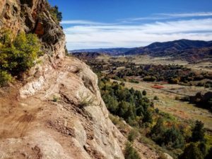
The 2018 Jeffco Resident Survey reflected that 75% of respondents were in favor of designating trails for a single type of use. In addition, the 2014-2019 JCOS Master Plan identifies the objective to evaluate different management types on existing trails. Considering these factors, along with additional considerations, JCOS decided to implement a pilot program to evaluate designated use trails.

The pilot program evaluated the challenges and benefits associated with designated use trails. During this time, Jeffco Open Space collected data, conducted surveys with all visitor types, and solicited feedback about visitors’ overall experience on the trail.

Approximately 80% of all visitors surveyed were satisfied or in favor of the designation for the Dakota Ridge South Trail. Jeffco Open Space also collaborated with the regional mountain bike community, who provided valuable insight and feedback. Based on this data and positive comments collected from visitors, Jeffco Open Space made the decision to make the designation permanent.

Dakota Ridge South Trail will go from a pilot program to a mountain bike only designation on November 1, 2019 and will be signed to reflect this change.

To learn more about designated use trails in Jeffco Open Space parks, visit www.jeffco.us/3817/Designated-Use.

Matthews Winters Open Space Park map


Jeffco Open Space was founded as a land conservation organization in 1972. Our mission is to preserve open space and parkland, protect park and natural resources, and provide healthy, nature-based experiences. Funded with a one-half of one percent sales tax, our organization contributes to city and park district projects, has preserved more than 56,000 acres, and manages 27 open space parks and more than 244 miles of trails in Jefferson County, Colorado.

For more information contact: Matt Robbins, Community Connections Manager,

mr******@je****.us


or 303.271.5902


Photo of black bear trail.

Rugged New Black Bear Trail for Advanced Users Only

By Vicky Gits

The section on the Black Bear Trail called The Ledge is for adventurous hikers and bicyclists. Photo by Nathan McBride

With 65 switchbacks in only 6.3 miles and a stunning cliff feature with a 50-foot drop, the new Black Bear Trail is one of the most challenging in the Jefferson County Open Space park system.

The trail connects two parks in South Jeffco, Deer Creek Canyon and Hildebrand Ranch. (For details see map at jeffco.us/parks, Deer Creek Canyon Park)

The Black Bear trail gets its name from the first attempt to build it in 1994, when workers on the downhill leg into Mill Creek at the time saw a black bear.

Later that year, trail construction came to an unexpected halt when an easement deal around the hogback near Hildebrand fell through. Twenty years later, Open Space revisited the idea of completing the trail, but on a different path.

Construction began Oct. 2016. Most of the work was in summer 2017. The trail opened in 2018.

The route starts near the summit of Plymouth Mountain and goes east, across two hogbacks, mostly downhill to Hildebrand Ranch trailhead.

The trail is open now but is closed seasonally for nesting raptors from Feb. 1 to July 31.

“Not for the squeamish”

Courtesy of Jeffco Open Space.

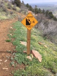
Sign on Black Bear Trail alerts bicyclists to dangerously exposed area known as The Ledge.

“When it first opened, people were pretty much amazed by it, especially when they hit the area called The Ledge,” said Jason Crum, Trails Team Lead, South Region.

The stretch that comprises the ledge is naked rock, no trees and nothing to halt a falling hiker or bicycle, as a warning sign amply illustrates. The Ledge looks precarious in photos, but is manageable at least 3- to 4-feet wide and is less steep and more sustainable than the alternative, Crum said.

It’s not all about The Ledge, though. Jeffco outdoor writer ] Steve Knapp said he appreciates the ecological and geological variety. “From dense pine forests you pass through high meadow before beginning to climb the first of two low hogbacks that stand in the way of Hildebrand.

“These two ridges offer a taste of high prairie, well-seasoned with flavors of the Southwest.  Climbing the first ridge, the trail passes along a lofty stone ledge that, while not for the squeamish is unique within the JCOS system,” Knapp said.

The construction team consisted of about 10 people per day and included members of the Jefferson County Trail Stewardship Team, Team Works and the Mile High Youth Corps.

50 to 60 percent of steep

“The most difficult aspect of the build was the steepness of the side slope,” Crum said. “We shot anywhere from 50 to 60 percent (steepness) on up.” But with so many switchbacks the trail averages only about 10 percent grade, which is a system standard.

Another challenge was chewing through hogback bedrock. “We had to use a thing called Boulder Blaster, which uses water to fracture the rock, and a lot of jack-hammering,” Crum sai

No bailing out

Black Bear is not for the beginning hiker.  It is rated difficult or black diamond in the park system’s rating system, primarily because it’s so long.

Endurance is the main issue, especially if it’s hot weather.  Once you commit, there is no place to bail out, Crum said.

It’s about a 10-mile trip to make the circle from Hildebrand Ranch to Plymouth Mountain and Deer Creek Canyon Park.  But many hikers start at Hildebrand, which entails a 15.8-mile journey to the start of Black Bear at the top of the mountain and back again. Hikers can save a couple of miles by staying on the road.

Courtesy of Jeffco Open Space

The Black Bear Trail travels through various ecosystems.

Black Bear Trail, a serious workout for bikers, hikers and especially the adventurous, but with plenty to offer the energetic nature-lover, as well.

********

TIMELINE

Black Bear Trail

Connecting Hildebrand Ranch Park to Deer Creek Canyon Park

Jefferson County Open Space

1994: Black Bear Trail built from Plymouth Mountain to Mill Creek and terminated at the second hogback from top. Trail is open to public but seldom used.

Oct. 2016: Construction begins again

Summer 2018: Trail opens for mountain bikes, hikers and equestrians


TRAIL FACTS

Info and Map:  jeffco.us/parks, Hildebrand Ranch Park and Deer Creek Canyon Park. See both maps before setting out on hike.

65 switchbacks

6.3 miles length

6800 feet elevation at start on mountain

5750 feet elevation at Hildebrand Trailhead

10 percent average grade of trail

50 to 60 percent average grade of slope (90 to 100 percent is a vertical wall)

Surface and width: natural surface, 3 to 4 feet wide

The Ledge: 2.1 miles from the start of Black Bear Trail and Two Brands Trail to The Ledge

4,071 feet of chain link fence removed

3,443 feet of installed wildlife friendly HTF range fence

The wildlife-friendly fence is 3 ½ ft. tall with six strands of smooth wire vs. chain link fence that is 6 ft. tall. The wildlife fence is designed to allow easier movement for animals.

2,885 feet of installed chain link fence

4.8 miles of trail on Open Space property

1.5 miles on Lockheed Martin property using and easement agreement (mostly contained by new fence)

2.6 miles of trail built by contractor Arrowhead Trail

3.7 miles built by Jeffco Open Space